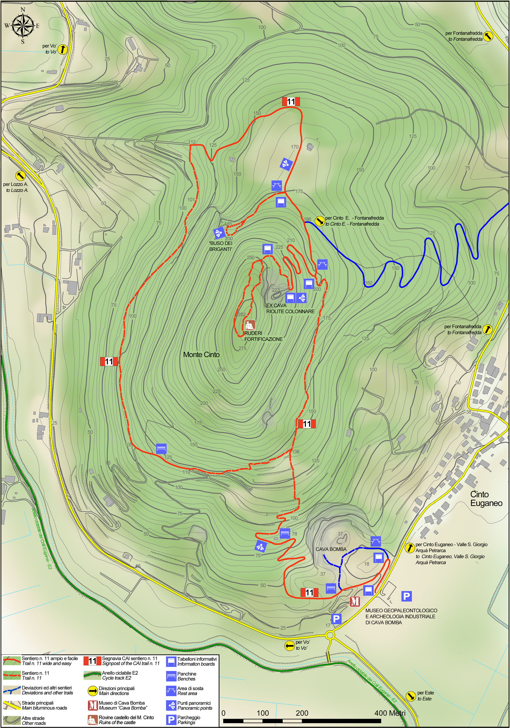
No 11 - Mt. Cinto Trail


- Departure: Loc. Cava Bomba - Cinto Euganeo (Cinto Euganeo)
- Arrival: Loc. Cava Bomba - Cinto Euganeo (Cinto Euganeo)
- Duration: 1 hour 30 minutes
- Difficulty Level: E - Hiking (level)
- Length: 4.9 km
- Difference in height: 267m
- Involved Municipalities: Cinto Euganeo
- Show the map
The trail starts 100 metres away from the square outside the Cava Bomba geo-paleontological museum on the left-hand side of the road, towards the town centre of Cinto Euganeo.
The trail climbs the chalky southern slope of Mount Cinto. After passing by a stone cottage, it runs along the edge of a terraced vineyard surrounded by olive trees and then climbs through a forest of black locust trees. Keep walking along the bridleway that crosses a thermophile oak forest full of white oak, South European flowering ash, tree heather, rock-rose, butcher’s broom and wild asparagus. After a short uphill bend with a wooden fence, you’ll reach level ground where the old dirt road once used by rhyolite quarrymen ends up. Here you’ll come across masegne: volcanic blocks of stone used as park benches. From the level ground, keep left and walk along the bridleway through the chestnut forest. After a few gentle bends in the road, the view looks out over the central-southern hills from Mount Venda to nearby Gemola and Villa Beatrice d’Este, as far as distant Mount Rua and the hills of Monselice and Baone.
No 11 - Mt. Cinto Trail
 Download KMZ
  Download in GPX format
en
An excellent spot to view the shape of the terrain in the Euganean Hills, the path ends up at the entrance of a quarry of rhyolite columns; the view that greets you when you enter this majestic amphitheatre - with all due caution - is spectacular: long columns of rhyolite only partially covered by vegetation still clearly and strikingly demonstrate their volcanic origins.
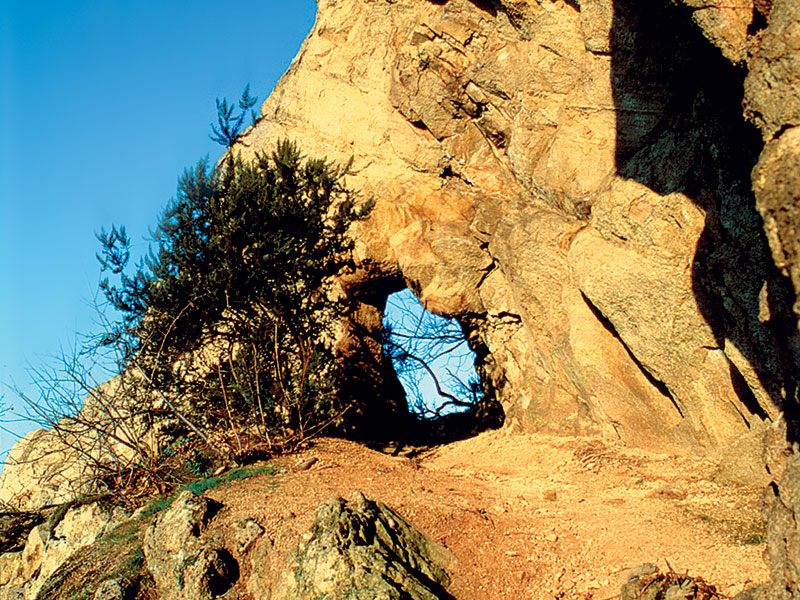
Once you leave the quarry, the path immediately to your left leads to the top of Mount Cinto after a brief uphill climb, a summit occupied by the ruins of its medieval castle. The circular path continues downhill near the volcanic rock park benches on level ground, keeping the bridleway on the left. Just before entering a newly replanted forest of black pine, take a detour, also on the left, which soon reaches a picnic area. We recommend the detour for Buso dei Briganti, one of the most impressive sites in the Euganean Hills.
Once you’ve returned to the picnic area, continue along the trail as it slopes downhill along the edge of a field and then a forest on the northern slope, taking care to keep an eye out for a detour that is signposted in order to avoid inaccessible areas, near farmland and a bee farm.
Having reached the main path once more, the trail rises and falls as it crosses the chestnut coppice of the western slope. Here you’ll come across spots with cement blocks placed in order to stop vehicles from continuing any further, after which you should always keep to the left.
You’ll then find yourself among the vineyards of the south-facing hillside once more, crossing them along a wide path or skipping them along a narrow, slightly uphill detour that crosses black locust woods, and finally ending up back in Cava Bomba.
